
• About
  • Advertise
  • Contact
Thursday, July 16, 2026
Newsletter
Global Highways
  • News
  • Products
  • Features
  • Categories
    • Asphalt Milling, Paving & Compaction
    • Concrete Milling, Paving & Compaction
    • Connected Construction
    • Earthmoving & Soil Compaction
    • Engines, Components & Tyres
    • Finance & Funding
    • Highway & Network Management
    • Maintenance
    • Materials
    • Recycling
    • Road Markings, Barriers & Workzone Protection
    • Road Structures
  • Events
    • Events Calendar
    • CONEXPO-CON/AGG 2026
    • Intertraffic Amsterdam 2026
    • bauma 2025
  • Latest Magazine
  • Videos
No Results
View All Results
  • News
  • Products
  • Features
  • Categories
    • Asphalt Milling, Paving & Compaction
    • Concrete Milling, Paving & Compaction
    • Connected Construction
    • Earthmoving & Soil Compaction
    • Engines, Components & Tyres
    • Finance & Funding
    • Highway & Network Management
    • Maintenance
    • Materials
    • Recycling
    • Road Markings, Barriers & Workzone Protection
    • Road Structures
  • Events
    • Events Calendar
    • CONEXPO-CON/AGG 2026
    • Intertraffic Amsterdam 2026
    • bauma 2025
  • Latest Magazine
  • Videos
No Results
View All Results
Home Products EarthSense Systems releases air pollution map of the UK

EarthSense Systems releases air pollution map of the UK

EarthSense Systems has published MappAir, a high-resolution map of air pollution throughout the entire UK. MappAir shows how air pollution - specifically nitrogen dioxide - changes across the country and within towns and cities, highlighting likely sources and potential clean-air refuge areas. It combines data from satellites and its EarthSense Systems’ own air quality monitoring sensors along with open source data. The result, using complex modelling, creates a highly accurate map at 100m resolution, says

by Sarah Biswell
June 16, 2018
in Products
Reading Time: 3 mins read
A A
EarthSensePollutionMap-PIC1.jpg

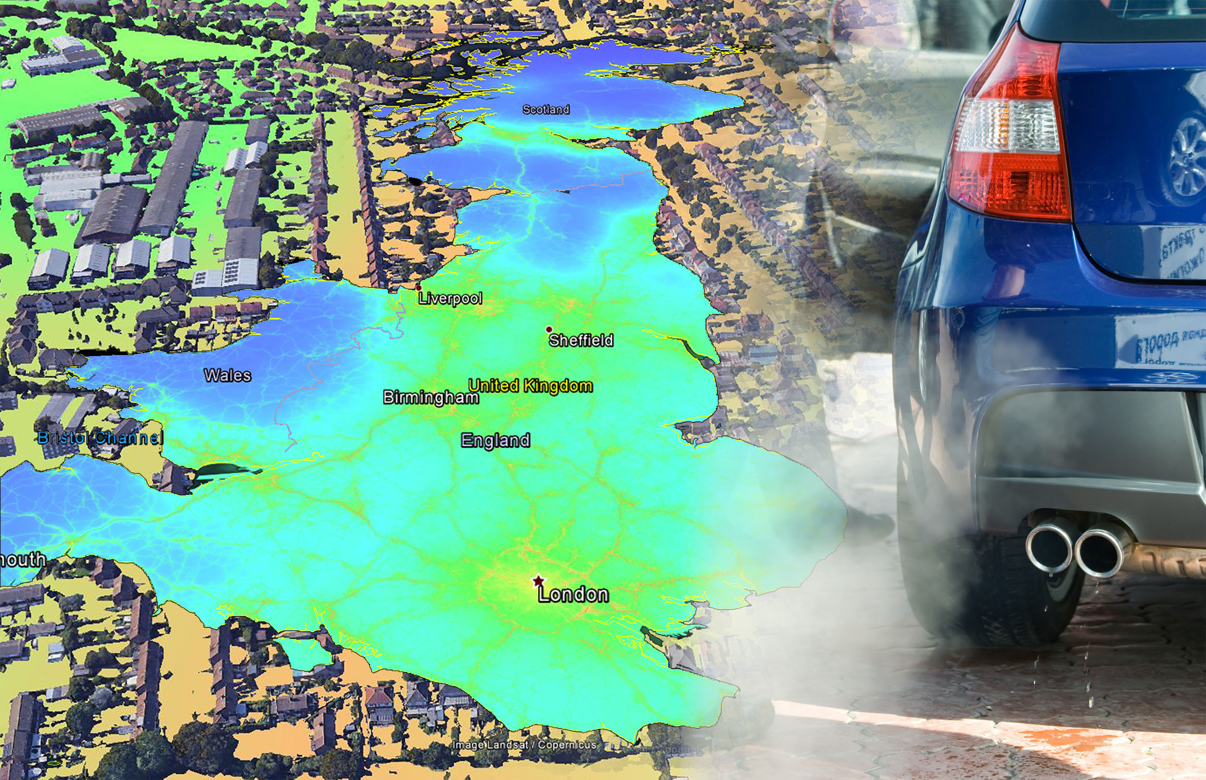
The comings and goings of the UK’s air pollution, according to MappAir, a high-resolution map

EarthSense Systems has published MappAir, a high-resolution map of air pollution throughout the entire UK

MappAir shows how air pollution – specifically nitrogen dioxide – changes across the country and within towns and cities, highlighting likely sources and potential clean-air refuge areas.

It combines data from satellites and its EarthSense Systems’ own air quality monitoring sensors along with open source data. The result, using complex modelling, creates a highly accurate map at 100m resolution, says James Eddy, managing director of EarthSense Systems.

“There simply isn’t enough [air quality] data available for those charged with tackling the issue to make informed decisions. MappAir provides a street-view to citywide visualisation of air pollution and is the first in a series of nationwide products that are coming to market in the next year.”

Using the British National Grid, EarthSense has divided the UK into 100m-squares – about twice the size of an average football pitch. Air pollution readings from satellites and its own Zephyr air quality monitoring sensors are combined with open data, including traffic emissions and weather conditions, to produce an annual average for each cell.

As additional sensors come online and more historical data becomes available, EarthSense says that it will produce a range of MappAir products. These include an ultra-high resolution 1m dataset for detailed study areas and a 10m map for urban areas. There will be a historic time series of maps showing how air pollution changes over the course of a day and on different days. Forecast maps will give an indication of fluctuations up to three days ahead.

EarthSense will also be releasing a map of PM2.5 – ultrafine pollution particles smaller than 2.5 micrometres. “Not only does it differ from location to location, as MappAir clearly shows, but it also changes from morning rush hour to afternoon school run and from weekday commutes to weekend leisure pursuits,” says Eddy. “This is why we are already working on the next products in the MappAir range, including near real-time altering maps and forecast maps.”

EarthSense has already undertaken a range of air quality monitoring projects, including trials of an airborne air quality mapper, air pollution monitoring equipment on a rocket and mobile mapping with air quality sensors mounted in electric cars. Future plans include the establishment of a nationwide network of air quality monitoring sensors that will feed live data for up-to-the-minute air quality predictions.

EarthSense Systems is a joint venture between UK aerial mapping company Bluesky and the University of Leicester in the UK. Bluesky is a specialist in aerial surveying including aerial photography, LiDAR and thermal data. It uses survey technology, including two UltraCam Eagles and a Teledyne Optech Galaxy LiDAR system integrated with a PhaseOne camera and thermal sensor.

EarthSense is also developing solutions for other environmental applications, including a National Tree Map, solar mapping and citywide heat-loss maps.

Related Posts

(Image: CIFA)

CIFA introduces the new K60H with 7-section boom: a new benchmark in the 60-metre class

by Sarah Biswell
July 10, 2026

CIFA expands its CARBOTECH range with the introduction of the new K60H with 7-section boom, a truck-mounted concrete pump designed...

Better visibility, more order, more convenience: The new SUPER 800-5 P min paver from Vögele offers numerous advantages.

Market launch for new mini road paver from Vögele

by Sarah Biswell
July 6, 2026

Market launch for new mini road paver from Vögele

The W 200 F combines high milling performance with innovative automation solutions and. in particular, addresses the needs of users looking for efficiency and flexibility in a compact machine concept.

The W 200 F with MILL ASSIST impresses on the Latin American market

by Sarah Biswell
July 6, 2026

The large milling machine combines smart machine control with automated documentation

Join our newsletter

The mission of Global Highways is to cover the latest technologies and best practices in all areas of road, bridge and tunnel construction and maintenance, as well as their safe operation and management.

Subscribe to our newsletter

About Us

  • About Us
  • Advertise
  • Contact
  • Terms & Conditions
  • Privacy Collection Notice
  • Privacy Policy

Popular Topics

  • News
  • Features
  • Products
  • Videos
  • Events
  • CONEXPO-CON/AGG 2026
  • Intertraffic Amsterdam 2026
  • bauma 2025

© 2026 All Rights Reserved. All content published on this site is the property of Prime Creative Media. Unauthorised reproduction is prohibited

No Results
View All Results
NEWSLETTER
  • News
  • Products
  • Features
  • Categories
    • Asphalt Milling, Paving & Compaction
    • Concrete Milling, Paving & Compaction
    • Connected Construction
    • Earthmoving & Soil Compaction
    • Engines, Components & Tyres
    • Finance & Funding
    • Highway & Network Management
    • Maintenance
    • Materials
    • Recycling
    • Road Markings, Barriers & Workzone Protection
    • Road Structures
  • Events
    • Events Calendar
    • CONEXPO-CON/AGG
    • Intertraffic Amsterdam 2026
    • bauma 2022
  • Latest Magazine
  • Videos
  • About
  • Advertise
  • Contact

© 2026 All Rights Reserved. All content published on this site is the property of Prime Creative Media. Unauthorised reproduction is prohibited