The machine control sector has been lively in recent months with a major acquisition, the unveiling of new software innovation and landmark testing of new technology to monitor paving temperature. Guy Woodford reports The state road construction authority in the German state of Saxony-Anhalt (LSBB Saxony-Anhalt) has become the first nationally to test MOBA’s new PAVE-IR Scan temperature measurement system at a works site.
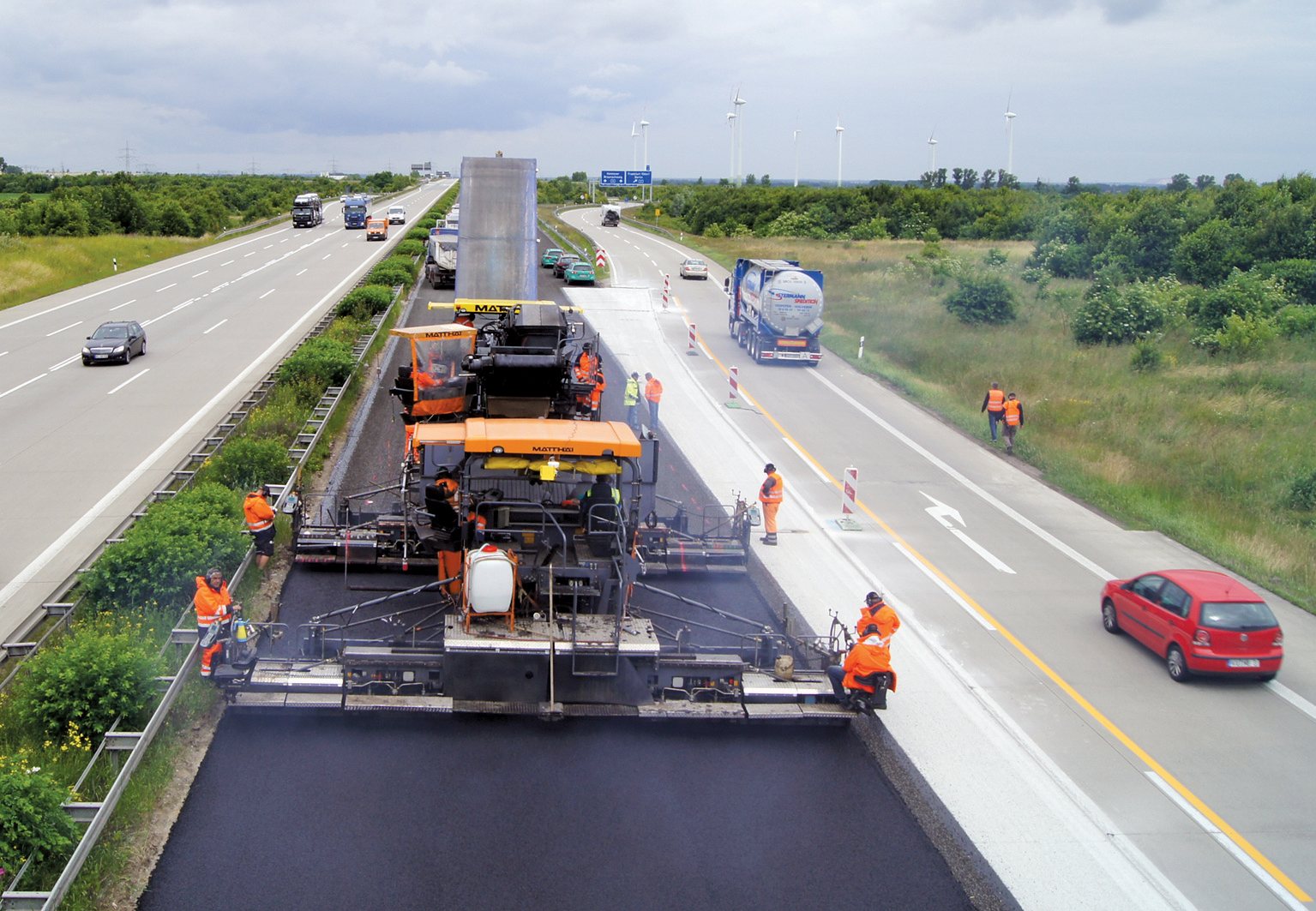
In the first section of the asphalt resurfacing on the A14 in Germany, MOBA’s PAVE-IR system scanned the asphalt temperature over a width of about 8.5m
The machine control sector has been lively in recent months with a major acquisition, the unveiling of new software innovation and landmark testing of new technology to monitor paving temperature. Guy Woodford reports
The state road construction authority in the German state of Saxony-Anhalt (LSBB Saxony-Anhalt) has become the first nationally to test1228 MOBA’s new PAVE-IR Scan temperature measurement system at a works site.
With MOBA’s new system, the temperature is measured over the entire area during paving. Using this data, it is possible to draw conclusions about possible weak points in the road.
More and more vehicles travel motorways and place increasing strain on the roadways. Due to these high loads and because of construction defects, roads often crack after just a few years and potholes and ruts form. This also means additional work for new construction and maintenance measures. The number of traffic jams is increasing as well, leading to immense, secondary economic costs. At the same time, the costs for road construction in Germany have risen by a quarter since 2005. This makes it crucial for the responsible authorities, such as LSBB Saxony-Anhalt, to achieve optimum results when constructing and resurfacing roads in order to increase the longevity of the roadways and avoid premature repair work and its additional costs.
In cooperation with the construction company4902 Matthäi, LSBB Saxony-Anhalt tested the PAVE-IR Scan quality control system for temperature measurement during the partial asphalt resurfacing of a section of the A14 near Magdeburg.
Around 15,000 motor vehicles roll over the ageing motorway every day. For the repaving works, the concrete surface was removed on a 1km long north lane section over a width of about 8.5m. A new asphalt binder layer and asphalt surface layer were then paved. Matthäi, the building contractor, performed the work with hot-on-hot paving, in which two pavers, travelling one behind the other, paved the binder layer and surface layer as compact asphalt. The components of the PAVE-IR Scan system were installed on the paver used for the surface layer. The temperature of the binder layer was also recorded. During the second phase of construction, paving was performed over a width of 10.5m.
Because LSBB Saxony-Anhalt is responsible not only for the tendering of construction projects, but also for inspections during the construction work, they inspect the building materials, the paving process and the completed roads for all projects. The results of the inspections are decisive for approval, billing and the guarantee which the company that performs the work must provide, for example if faulty material is used during paving.
In addition to inspections of the asphalt mix during paving, selective core samples are taken upon completion of the project. These core samples are used to, among other things, determine the compaction and the void content of the paved layers and, thus, test the quality of the road.
PAVE-IR Scan consists of a temperature scanner, a GNSS antenna for precise position determination and an onboard computer. Additional, optional sensors, such as a weather station or individual temperature sensors, can be integrated. At the start of the project, the user enters the project data, for example the starting location and the kilometre point, using the onboard computer. The temperature of the surface layer is measured by the infrared scanner over the entire paving width. For this purpose, the sensor scans the paved asphalt temperature every 25cm with an accuracy of Plus/minus 2°C.
The current position data as well as the waypoints are recorded by the system via a GNSS antenna. This information can, however, also be complemented by the machine data. All temperature data is displayed on the onoard computer as measurement points together with data such as wind speed, air temperature and humidity, position data, distance covered and average speed of the paver. At the same time, all of this information is stored for documentation and evaluation.
To function reliably at the construction site, all electronic components in the system are specially protected for use outdoors against penetration by dust and water and against damage by heat and vibrations.
Upon completion of the A14 paving work, the stored data was evaluated with the PAVE Project Manager software. The temperature profile, which was recorded for the entire construction project, clearly showed how hot the asphalt was during paving at a given position. In this way, it was possible to draw conclusions about the quality of the road, since the temperature during paving is a decisive factor for a high-quality result.
During the resurfacing of a state road in the coming year, LSBB Saxony-Anhalt will again use the PAVE-IR Scan and, following this second test project, decide how to integrate this new option in tenders.
Dittmar Marquordt, department head of LSBB Saxony-Anhalt, said, “We can see great advantages in using the system. For the first time, it is possible to monitor the temperature over the entire area and thereby perform an indirect quality control for entire projects. This can be used both as a control tool and as an optimisation instrument. The temperature profile benefits not only us as authorities, but it also serves as proof of good work for the construction company.”
Marquordt added that LSBB Saxony-Anhalt would consider incorporating a PAVE-IR Scan-type system as a standard part of tenders for larger projects. After the end of the first test series, there will be further PAVE-IR tests at the beginning of 2014. The system is expected to be available for the European market in early summer 2014.
342 Topcon Positioning Group has announced the acquisition of Dynaroad, a construction software company in Helsinki, Finland. The Topcon Helsinki Technology Centre is being created following the major machine control sector Deal.
In 2011, Topcon Positioning Systems (TPS) acquired a significant share of2601 Dynaroad, a company that develops project management software specifically designed for large-scale construction projects – including highway, tunnel, and railway works.
Of the 100 per cent acquisition of Dynaroad, Ray O’Connor, TPS president and CEO, said, “Contractors and designers who are
looking to cut construction costs through design optimisation and better task management now have a strong central source for production management with Dynaroad being integrated to other Topcon systems.
“The new technology center in Helsinki has a strong foundation as the team has already worked with Topcon for approximately four years. We look forward to releasing new world-class products with them.”
O’Connor said the Dynaroad software combined with Topcon’s Sitelink3D ENTERPRISE, a real-time task management tool, creates “an integrated machine control solution for all phases of earthworks projects, from pre-planning to construction.”
Meanwhile at InterGEO 2013, the annual international conference and exhibition for geodesy, geoinformation, and land management, Topcon announced the GLS-2000 laser scanner designed for ease of use in any job situation.
“An expanded field-of-view, high speed and compact size make it the most versatile, best-in-class laser scanner suitable for any job site,” said Ian Stilgoe, geomatics unit business manager for Topcon Europe Positioning.
With its 350m eye-safe long-range scanning technology, the GLS-2000 features survey-grade accuracy that reduces the amount of scan setups required on site. The integrated twin cameras help ensure that the images recorded provide the best possible definition photography for all levels of scan detail.
Its dual-axis compensators provide tighter registration, overall increased accuracy, and increased field flexibility to help meet the needs of unique site logistics and project situations.
“The bottom line,” Stilgoe said, “is that the GLS-2000 is easy: easy to set up, easy to operate, and it provides an easy pathway to post-processing of data collected. Put these factors together with Topcon’s unique scan technology and you are increasing productivity and your company’s bottom line on every project.”
Topcon has also announced the addition of Vanguard technology to the GRS-1 handheld GNSS receiver and field controller.
Scott Langbein, director of product marketing, said, “With the addition of Vanguard technology, the GRS-1 fully integrated, dual-constellation, network-enabled receiver and controller optimises tracking and performance regardless of job site conditions or location.”
Topcon’s exclusive 226-channel Vanguard technology with Universal Tracking allows each individual GNSS channel to be fully optimised to track any of the available satellite signals that are supported in today’s modern GNSS receivers.
The GRS-1 can be used in various configurations from handheld to network enabled RTK measurement, and grade management. “The system can be configured to perform at various levels of accuracy that fit any budget and application,” Langbein said. Choices include centimetre level, sub-decimetre and sub-metre, with accuracy upgradeability options available.
Working with Topcon’s MAGNET suite of software products, the GRS-1 is said by Langbein to “streamline the workflow for surveyors, contractors, engineers and mapping professionals."
The GRS-1 with Vanguard has DGPS capability with the internal single frequency antenna for use in GIS and navigation applications. Users can add the external antenna and connect a GRS-1 rover to a local GNSS network, or Topcon MAGNET Relay, for centimetre accuracy RTK performance. MAGNET Relay allows a mobile base receiver to host up to 10 rovers through the MAGNET Enterprise “cloud”.
The GRS-1 has an optional 2MP built-in camera, integrated SD memory card slot, and includes an optional internal GSM or CDMA cellular modem and internal GNSS antenna, Plus wireless connectivity via wireless LAN or Bluetooth technology.
Swedish contractor Ytterviks Maskin is said to have completed a local infrastructure project faster and correctly first time by using the new Leica iCON grade for wheeled loaders machine control system.
Wheeled loader operator Joakim Ostensson added the final touches to pedestrian and cycle paths near Skellefteå in late September using his brand new2394 Volvo L60G wheeled loader, equipped with 265 Leica iCON grade for wheeled loaders, featuring Dual GNSS.
The system helped him to do both rough grading and final fine touches with a very high degree of precision, even on soft or rough terrain with challenging materials. Wheeled loaders are faster than dozers, are especially mobile and do not damage paved roads.
With the Leica iCON 3D machine control system, Ostensson performs these tasks at high speed and can also swiftly perform control measurements for as-built records with centimetre precision.
Using the Leica iCON system, Ytterviks Maskin saves time and material by excavating exactly what was planned, thus also saving expensive fuel.
Ostensson said, “The major advantage is getting rid of all the staking out. No pegs, no stakes and batter boards sticking out of the ground all over the site. I save a lot of time with the system, because there is no machine downtime caused by stake out or height level checking tasks. I already know what needs to be done on the project since I have all the data with me in the cab.”
Design information and real-time cut and fill indications are displayed on the control panel in the cab where Ostensson has the full picture of the project. The panel user interface with graphical colour display provides full guidance and allows easy operation. Leica Geosystems’ 3D machine control system for wheeled loaders uses modern GNSS technology for accurate positioning including earthmoving results.
The dual GPS solution provides Ostensson with the real-time position of the bucket allowing him to make instantaneous adjustments to keep the level of material where it needs to be.
Ostensson’s new machine control system features the innovative patented PowerSnap functionality for fast exchange of control panels between machines at Ytterviks Maskin. Leica iCON also supports Leica iCON telematics which enables users to easily transfer data from office to machines, receive remote support and utilise basic fleet management via the iCONnect website.
Trimble’s new TyrePulse Tyre Monitoring System
2122 Trimble’s new TyrePulse Tyre Monitoring System assists fleet managers in reducing maintenance costs, increasing overall fleet productivity and promoting site safety
Part of the Trimble Connected Site portfolio, the advanced machine monitoring solution wirelessly reports tyre temperature and pressure data from the jobsite to the VisionLink fleet, asset and site productivity management solution from Trimble. Automatic, real-time tyre pressure and high-temperature alerts help fleet managers and site supervisors schedule cost-effective preventative tyre maintenance, extend the life of tyre, increase fuel efficiency and avoid dangerous blowouts.
Under-inflated tyre can reduce fuel economy, increase overheating, tread wear and blowouts that take a machine out of production. Together, these factors can significantly affect fleet productivity and operating costs.
Trimble TyrePulse can improve tyre life while also reducing the need for fleet managers to drive to the site and visually inspect inflation, tyre wear and temperature. Using a Trimble TP920 Industrial Tyre Sensor in the tyre valve stem and a Trimble SNM940 Connected Site Gateway for communications, the information is automatically relayed back to the office for analysis by the fleet manager. Accurate data is communicated through VisionLink, so the fleet manager can proactively manage tyre maintenance on more machines across construction sites. Better preventative maintenance can result in improved fleet costs.
The Trimble TyrePulse system also promotes increased jobsite safety by reducing the risk of tyre blowout and injury to workers. Properly inflated tyres improve the performance of vehicle braking systems and allow a faster response time in potentially dangerous conditions. The system is also safer and more accurate than manual visual inspection because it does not require personnel to be in close proximity to overheated tyres on heavy machinery.
VisionLink automatically alerts the fleet manager or site foreman when a tyre experiences a 20% drop in pressure and becomes a potential hazard. It can also provide a high-temperature alert to indicate that jobsite conditions are likely to accelerate tyre breakdown.
“Preventative maintenance is more cost-effective than a machine going down suddenly with a blown tyre. But with equipment moving around so much from site to site, fleet managers struggle to stay ahead of the game,” said Julian Dann, business area director for machine control. “TyrePulse is priced for installation across the entyre fleet of on- and off-road machine tyres, regardless of make, model or manufacturer. Increased wear or breakdown can be reported and acted upon proactively. The system can often pay for itself by preventing just one blowout.”
VisionLink version 2.8 and the new Trimble TyrePulse Tyre Monitoring System are currently available through the Trimble SITECH Technology Dealer Channel in North America.
Prolec machine guidance rental scheme
309 Prolec has launched a machine guidance system rental scheme designed to allow operators to gain the benefits of using advanced tools at a lower cost.
Aimed at operators who have a one-off job that requires machine guidance, or those who would like to trial a system before committing to it, the rental scheme makes Prolec’s guidance systems accessible to smaller companies where expenses need to be matched closely to income.
Prolec’s rental scheme covers all of its machine guidance products – Digmaster, Digmaster Pro and pcX Pro. Offering 2D and 3D guidance through to a GPS set up, the rental systems range from simple to extremely complex, with a wide range of tools and machine options. They boast advanced graphics and simple operator interfaces.
GPS can be provided from Prolec’s own supplier, or can be incorporated into an existing GPS system, as Prolec products are set up to be compatible with 99% of all GPS providers worldwide. Full training is provided to ensure operators are confident in using the system, and that it can be used to its full capacity, thus gaining the most benefit from the rental cost.
This scheme is being offered through all Prolec distributors, giving customers the chance to try out its machine guidance products risk-free, for the duration they are needed. Additionally, any customer deciding to subsequently buy the kit will be refunded 50% of the rental cost. Or if it is no longer needed, the kit will be removed at no additional cost.
Machine rental companies, with support from the Prolec distributors, are also able to support this scheme. Two of Prolec’s distributors – Hubbway Plant and Tool Hire in North East England and Bastable Plant Hire in South East England – are already providing this service as they offer plant hire alongside their other services. Both stock excavators from 5tonne to over 30tonne, including long reach, fitted with Prolec machine guidance. They can also supply excavators and telehandlers with the award-winning Prolec Machine Engine (PME) safety systems fitted as standard.
The state road construction authority in the German state of Saxony-Anhalt (LSBB Saxony-Anhalt) has become the first nationally to test
With MOBA’s new system, the temperature is measured over the entire area during paving. Using this data, it is possible to draw conclusions about possible weak points in the road.
More and more vehicles travel motorways and place increasing strain on the roadways. Due to these high loads and because of construction defects, roads often crack after just a few years and potholes and ruts form. This also means additional work for new construction and maintenance measures. The number of traffic jams is increasing as well, leading to immense, secondary economic costs. At the same time, the costs for road construction in Germany have risen by a quarter since 2005. This makes it crucial for the responsible authorities, such as LSBB Saxony-Anhalt, to achieve optimum results when constructing and resurfacing roads in order to increase the longevity of the roadways and avoid premature repair work and its additional costs.
In cooperation with the construction company
Around 15,000 motor vehicles roll over the ageing motorway every day. For the repaving works, the concrete surface was removed on a 1km long north lane section over a width of about 8.5m. A new asphalt binder layer and asphalt surface layer were then paved. Matthäi, the building contractor, performed the work with hot-on-hot paving, in which two pavers, travelling one behind the other, paved the binder layer and surface layer as compact asphalt. The components of the PAVE-IR Scan system were installed on the paver used for the surface layer. The temperature of the binder layer was also recorded. During the second phase of construction, paving was performed over a width of 10.5m.
Because LSBB Saxony-Anhalt is responsible not only for the tendering of construction projects, but also for inspections during the construction work, they inspect the building materials, the paving process and the completed roads for all projects. The results of the inspections are decisive for approval, billing and the guarantee which the company that performs the work must provide, for example if faulty material is used during paving.
In addition to inspections of the asphalt mix during paving, selective core samples are taken upon completion of the project. These core samples are used to, among other things, determine the compaction and the void content of the paved layers and, thus, test the quality of the road.
PAVE-IR Scan consists of a temperature scanner, a GNSS antenna for precise position determination and an onboard computer. Additional, optional sensors, such as a weather station or individual temperature sensors, can be integrated. At the start of the project, the user enters the project data, for example the starting location and the kilometre point, using the onboard computer. The temperature of the surface layer is measured by the infrared scanner over the entire paving width. For this purpose, the sensor scans the paved asphalt temperature every 25cm with an accuracy of Plus/minus 2°C.
The current position data as well as the waypoints are recorded by the system via a GNSS antenna. This information can, however, also be complemented by the machine data. All temperature data is displayed on the onoard computer as measurement points together with data such as wind speed, air temperature and humidity, position data, distance covered and average speed of the paver. At the same time, all of this information is stored for documentation and evaluation.
To function reliably at the construction site, all electronic components in the system are specially protected for use outdoors against penetration by dust and water and against damage by heat and vibrations.
Upon completion of the A14 paving work, the stored data was evaluated with the PAVE Project Manager software. The temperature profile, which was recorded for the entire construction project, clearly showed how hot the asphalt was during paving at a given position. In this way, it was possible to draw conclusions about the quality of the road, since the temperature during paving is a decisive factor for a high-quality result.
During the resurfacing of a state road in the coming year, LSBB Saxony-Anhalt will again use the PAVE-IR Scan and, following this second test project, decide how to integrate this new option in tenders.
Dittmar Marquordt, department head of LSBB Saxony-Anhalt, said, “We can see great advantages in using the system. For the first time, it is possible to monitor the temperature over the entire area and thereby perform an indirect quality control for entire projects. This can be used both as a control tool and as an optimisation instrument. The temperature profile benefits not only us as authorities, but it also serves as proof of good work for the construction company.”
Marquordt added that LSBB Saxony-Anhalt would consider incorporating a PAVE-IR Scan-type system as a standard part of tenders for larger projects. After the end of the first test series, there will be further PAVE-IR tests at the beginning of 2014. The system is expected to be available for the European market in early summer 2014.
In 2011, Topcon Positioning Systems (TPS) acquired a significant share of
Of the 100 per cent acquisition of Dynaroad, Ray O’Connor, TPS president and CEO, said, “Contractors and designers who are
looking to cut construction costs through design optimisation and better task management now have a strong central source for production management with Dynaroad being integrated to other Topcon systems.
“The new technology center in Helsinki has a strong foundation as the team has already worked with Topcon for approximately four years. We look forward to releasing new world-class products with them.”
O’Connor said the Dynaroad software combined with Topcon’s Sitelink3D ENTERPRISE, a real-time task management tool, creates “an integrated machine control solution for all phases of earthworks projects, from pre-planning to construction.”
Meanwhile at InterGEO 2013, the annual international conference and exhibition for geodesy, geoinformation, and land management, Topcon announced the GLS-2000 laser scanner designed for ease of use in any job situation.
“An expanded field-of-view, high speed and compact size make it the most versatile, best-in-class laser scanner suitable for any job site,” said Ian Stilgoe, geomatics unit business manager for Topcon Europe Positioning.
With its 350m eye-safe long-range scanning technology, the GLS-2000 features survey-grade accuracy that reduces the amount of scan setups required on site. The integrated twin cameras help ensure that the images recorded provide the best possible definition photography for all levels of scan detail.
Its dual-axis compensators provide tighter registration, overall increased accuracy, and increased field flexibility to help meet the needs of unique site logistics and project situations.
“The bottom line,” Stilgoe said, “is that the GLS-2000 is easy: easy to set up, easy to operate, and it provides an easy pathway to post-processing of data collected. Put these factors together with Topcon’s unique scan technology and you are increasing productivity and your company’s bottom line on every project.”
Topcon has also announced the addition of Vanguard technology to the GRS-1 handheld GNSS receiver and field controller.
Scott Langbein, director of product marketing, said, “With the addition of Vanguard technology, the GRS-1 fully integrated, dual-constellation, network-enabled receiver and controller optimises tracking and performance regardless of job site conditions or location.”
Topcon’s exclusive 226-channel Vanguard technology with Universal Tracking allows each individual GNSS channel to be fully optimised to track any of the available satellite signals that are supported in today’s modern GNSS receivers.
The GRS-1 can be used in various configurations from handheld to network enabled RTK measurement, and grade management. “The system can be configured to perform at various levels of accuracy that fit any budget and application,” Langbein said. Choices include centimetre level, sub-decimetre and sub-metre, with accuracy upgradeability options available.
Working with Topcon’s MAGNET suite of software products, the GRS-1 is said by Langbein to “streamline the workflow for surveyors, contractors, engineers and mapping professionals."
The GRS-1 with Vanguard has DGPS capability with the internal single frequency antenna for use in GIS and navigation applications. Users can add the external antenna and connect a GRS-1 rover to a local GNSS network, or Topcon MAGNET Relay, for centimetre accuracy RTK performance. MAGNET Relay allows a mobile base receiver to host up to 10 rovers through the MAGNET Enterprise “cloud”.
The GRS-1 has an optional 2MP built-in camera, integrated SD memory card slot, and includes an optional internal GSM or CDMA cellular modem and internal GNSS antenna, Plus wireless connectivity via wireless LAN or Bluetooth technology.
Swedish contractor Ytterviks Maskin is said to have completed a local infrastructure project faster and correctly first time by using the new Leica iCON grade for wheeled loaders machine control system.
Wheeled loader operator Joakim Ostensson added the final touches to pedestrian and cycle paths near Skellefteå in late September using his brand new
The system helped him to do both rough grading and final fine touches with a very high degree of precision, even on soft or rough terrain with challenging materials. Wheeled loaders are faster than dozers, are especially mobile and do not damage paved roads.
With the Leica iCON 3D machine control system, Ostensson performs these tasks at high speed and can also swiftly perform control measurements for as-built records with centimetre precision.
Using the Leica iCON system, Ytterviks Maskin saves time and material by excavating exactly what was planned, thus also saving expensive fuel.
Ostensson said, “The major advantage is getting rid of all the staking out. No pegs, no stakes and batter boards sticking out of the ground all over the site. I save a lot of time with the system, because there is no machine downtime caused by stake out or height level checking tasks. I already know what needs to be done on the project since I have all the data with me in the cab.”
Design information and real-time cut and fill indications are displayed on the control panel in the cab where Ostensson has the full picture of the project. The panel user interface with graphical colour display provides full guidance and allows easy operation. Leica Geosystems’ 3D machine control system for wheeled loaders uses modern GNSS technology for accurate positioning including earthmoving results.
The dual GPS solution provides Ostensson with the real-time position of the bucket allowing him to make instantaneous adjustments to keep the level of material where it needs to be.
Ostensson’s new machine control system features the innovative patented PowerSnap functionality for fast exchange of control panels between machines at Ytterviks Maskin. Leica iCON also supports Leica iCON telematics which enables users to easily transfer data from office to machines, receive remote support and utilise basic fleet management via the iCONnect website.
Trimble’s new TyrePulse Tyre Monitoring System
Part of the Trimble Connected Site portfolio, the advanced machine monitoring solution wirelessly reports tyre temperature and pressure data from the jobsite to the VisionLink fleet, asset and site productivity management solution from Trimble. Automatic, real-time tyre pressure and high-temperature alerts help fleet managers and site supervisors schedule cost-effective preventative tyre maintenance, extend the life of tyre, increase fuel efficiency and avoid dangerous blowouts.
Under-inflated tyre can reduce fuel economy, increase overheating, tread wear and blowouts that take a machine out of production. Together, these factors can significantly affect fleet productivity and operating costs.
Trimble TyrePulse can improve tyre life while also reducing the need for fleet managers to drive to the site and visually inspect inflation, tyre wear and temperature. Using a Trimble TP920 Industrial Tyre Sensor in the tyre valve stem and a Trimble SNM940 Connected Site Gateway for communications, the information is automatically relayed back to the office for analysis by the fleet manager. Accurate data is communicated through VisionLink, so the fleet manager can proactively manage tyre maintenance on more machines across construction sites. Better preventative maintenance can result in improved fleet costs.
The Trimble TyrePulse system also promotes increased jobsite safety by reducing the risk of tyre blowout and injury to workers. Properly inflated tyres improve the performance of vehicle braking systems and allow a faster response time in potentially dangerous conditions. The system is also safer and more accurate than manual visual inspection because it does not require personnel to be in close proximity to overheated tyres on heavy machinery.
VisionLink automatically alerts the fleet manager or site foreman when a tyre experiences a 20% drop in pressure and becomes a potential hazard. It can also provide a high-temperature alert to indicate that jobsite conditions are likely to accelerate tyre breakdown.
“Preventative maintenance is more cost-effective than a machine going down suddenly with a blown tyre. But with equipment moving around so much from site to site, fleet managers struggle to stay ahead of the game,” said Julian Dann, business area director for machine control. “TyrePulse is priced for installation across the entyre fleet of on- and off-road machine tyres, regardless of make, model or manufacturer. Increased wear or breakdown can be reported and acted upon proactively. The system can often pay for itself by preventing just one blowout.”
VisionLink version 2.8 and the new Trimble TyrePulse Tyre Monitoring System are currently available through the Trimble SITECH Technology Dealer Channel in North America.
Prolec machine guidance rental scheme
Aimed at operators who have a one-off job that requires machine guidance, or those who would like to trial a system before committing to it, the rental scheme makes Prolec’s guidance systems accessible to smaller companies where expenses need to be matched closely to income.
Prolec’s rental scheme covers all of its machine guidance products – Digmaster, Digmaster Pro and pcX Pro. Offering 2D and 3D guidance through to a GPS set up, the rental systems range from simple to extremely complex, with a wide range of tools and machine options. They boast advanced graphics and simple operator interfaces.
GPS can be provided from Prolec’s own supplier, or can be incorporated into an existing GPS system, as Prolec products are set up to be compatible with 99% of all GPS providers worldwide. Full training is provided to ensure operators are confident in using the system, and that it can be used to its full capacity, thus gaining the most benefit from the rental cost.
This scheme is being offered through all Prolec distributors, giving customers the chance to try out its machine guidance products risk-free, for the duration they are needed. Additionally, any customer deciding to subsequently buy the kit will be refunded 50% of the rental cost. Or if it is no longer needed, the kit will be removed at no additional cost.
Machine rental companies, with support from the Prolec distributors, are also able to support this scheme. Two of Prolec’s distributors – Hubbway Plant and Tool Hire in North East England and Bastable Plant Hire in South East England – are already providing this service as they offer plant hire alongside their other services. Both stock excavators from 5tonne to over 30tonne, including long reach, fitted with Prolec machine guidance. They can also supply excavators and telehandlers with the award-winning Prolec Machine Engine (PME) safety systems fitted as standard.


